Connected Refugees

Par Quentin Lobbé, Doctorant en informatique et sociologie à Télécom ParisTech

À mesure que le train s’approche de Dunkerque, le relief se fait plus discret. S’affaisse. Répétitif, presque monotone. Au loin, la mer et – derrière – l’Angleterre pour seul horizon.

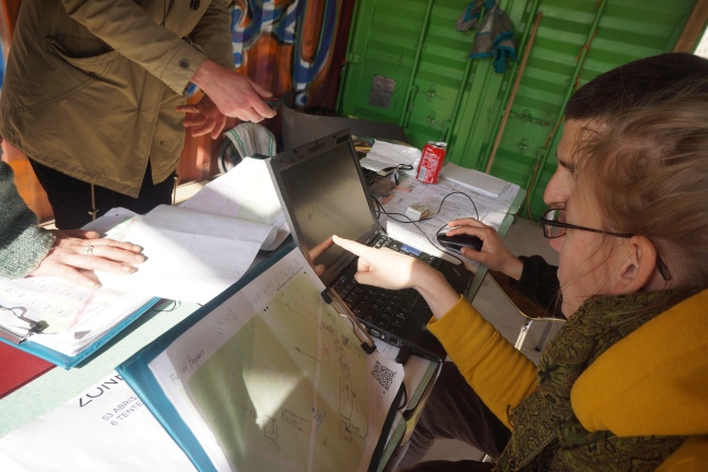
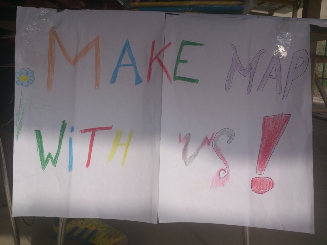
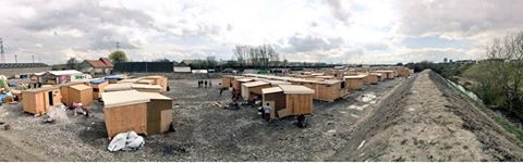
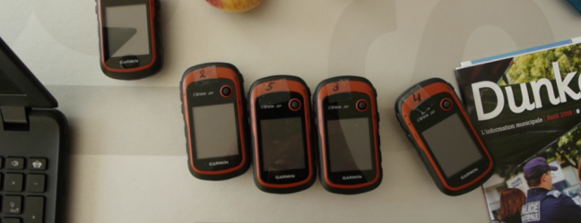
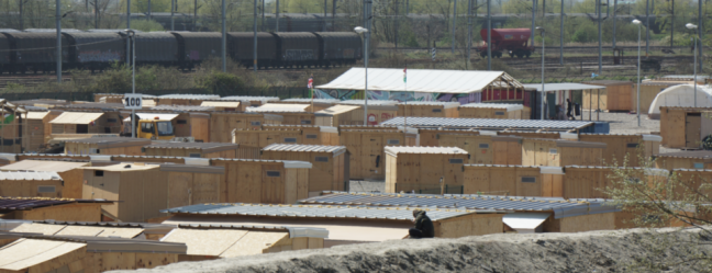
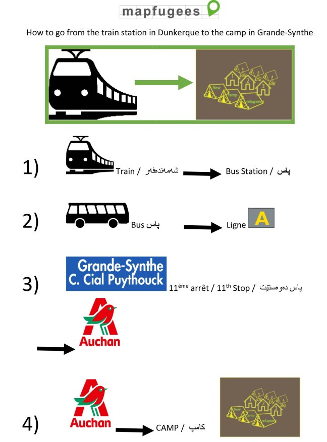
Je retrouve l’équipe de MapFugees : Katja, Jorieke et Johan. Ils sont là depuis une semaine déjà, éprouvés mais toujours aussi motivés. D’autres m’ont précédé, d’autres nous succéderons. L’équipe cherche à dresser une carte du camp de réfugiés de Grande-Synthe (proche de Dunkerque), nouvellement installé par Médecins sans frontières. La tâche n’est pas simple d’autant que nous partons de zéro : le camp était, il y a encore quelques semaines, une simple friche, les images satellites ne sont d’aucune utilité. Les résidents du camp participent au travail de cartographie, c’est une condition essentielle à la tenue du projet. Nous rassemblons rapidement le matériel, quelques ordinateurs, des clés 3G, des GPS, des chargeurs, des batteries et une montagne de Field Papers vierges ou déjà annotés. Le territoire occupé par le camp a été préalablement divisé en portions égales, imprimées sur papier en autant de Field Papers qui serviront de support à la récolte d’informations sur place. Chaque Field Paper est unique et porte la marque du binôme qui l’a édité : réfugié + bénévole + numéro du GPS + date, permettant de tracer et de suivre l’évolution du processus de cartographie de chaque zone.

Assembler les Field Papers, Dunkerque, Avril 2016
GPS, Dunkerque, Avril 2016

Nous nous mettons en route. Le bus quitte le centre de Dunkerque, longe le port, les quais et les ferrys en partance pour le Royaume-Uni. Nous arrivons aux abords d’une importante zone commerciale et industrielle prêt de Grande-Synthe. Il faut la traverser, longer routes et ronds-points et suivre un chemin balisé sur le terre-plein central d’une rocade avant d’atteindre le camp, dangereusement niché entre l’A16 et les lignes de trains reliant Dunkerque à Calais.

Grande Synthe, Avril 2016

Les liens que nous tissons nous décrivent, façonnent nos appartenances et nos idées. Ils nous renforcent et nous aident à nous construire, parfois à tenir. Avec l’apparition de la figure du migrant connecté [1], il a définitivement été établi que les migrants étaient acteurs d’une culture de liens, renforcé par l’usage des TIC, ravivant sans cesse la flamme d’une pulsion de présence entre le pays quitté et le pays atteint. Cette proposition n’a jamais été aussi vraie qu’à la vue du camp de Grande-Synthe.

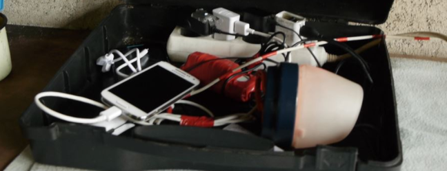
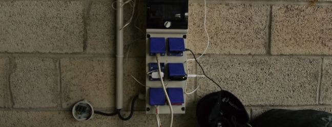
Le charging center est littéralement le cœur du camp, c’est le premier bâtiment que nous croisons une fois le seuil franchi. Bien avant les cuisines ou les points de ravitaillements en pétrole et vêtements. Des centaines de multiprises, de chargeurs et de câbles s’entremêlent, se croisent et se chevauchent sous ce vieux porche aménagé. Les réfugiés y patientent, discutent, échangent ou jouent au football en attendant que leurs batteries ne soient à nouveaux pleines.

Charging center, Grande Synthe, Avril 2016
« Boîte » à chargeurs, Grande Synthe, Avril 2016
Chargeurs, Grande Synthe, Avril 2016

Nous nous installons dos au conteneur qui sert de point d’accueil aux réfugiés. C’est un endroit stratégique et très passant où nous attirons le regard et la curiosité des résidents. Certains d’entre eux sont déjà là, habitués, ils nous attendent prêt à repartir cartographier. Après un rapide bilan, le processus de reconnaissance semble arriver à son terme, il ne reste que l’arrière du camp et les zones de vie (cuisines, échoppes, aires d’enfants…) à quadriller. Ces dernières sont particulièrement volatiles, de nouveau points d’intérêts apparaissent chaque jour, comme ce bike workshop qui n’était pas là la veille. Nous pourrions y revenir des dizaines de fois qu’il y aurait toujours quelque chose de nouveau à ajouter à la carte.

Comme je découvre le camp, A. – qui est arrivé à Grande-Synthe il y a une semaine à peine – se propose de m’accompagner et de m’enseigner la façon dont on cartographie les lieux. Il maîtrise déjà tous les outils. À ses côté je me sens élève brouillon, aux gestes mal assurés. Notre approche combine GPS et Field Papers qu’il annote. Nous remontons la Middle Road du camp, l’artère principale qui dessert toute la zone. Certains détails sont importants à relever comme cet alignement d’arbres qui délimitent un espace repas, des points de repères que l’on voit de loin, facile à identifier. Il s’agit plus de coucher sur papier la carte mentale qu’A. se fait du camp que de respecter des conventions de cartographes. Il faut avant tout respecter la construction que se font les résidents du camp. Quels en sont les frontières ? Les nœuds, les voies ou les repères visuels à la manière d’un Kevin Lynch [2].

Géolocaliser un point d’intérêt, Grande Synthe, Avril 2016

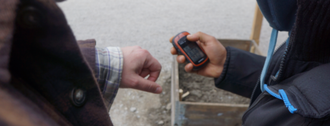
A. m’indique les points d’intérêts manquants que nous pointons grâce au GPS et dont nous précisons les fonctions. Il s’agit de bien nommer les choses, il me reprend à de nombreuses reprises, ce Coffee Shop ci est en réalité un Coffee & Tea Shop. A. navigue entre les shelters (abris en bois de 8 m² installés par MSF), construisant son propre parcours, révélant sa façon de percevoir les lieux. C’est la structure même du camp qui se dessine alors sous nos yeux. Qui vit où ? Les familles à l’avant, les célibataires à l’arrière, les écoles au centre du camp… La carte finale proposera plusieurs layers. Plusieurs couches pour plusieurs usages. Les bénévoles, la logistique, les associations, les résidents. Tous doivent s’emparer de cet outil.

Middle Road, Grande Synthe, Avril 2016

À mesure que nous nous enfonçons dans le camp, A. s’ouvre à moi. Cartographier le camp rompt avec la routine et l’ennui. Il raconte son histoire, sa vie d’avant, là-bas, au Kurdistan. Nous engageons la conversation avec d’autres réfugiés curieux de ce que nous faisons. A. en tire une certaine fierté, construire la carte noue des liens avec les résidents, avec les volontaires, avec chacun d’eux. Mais pour les réfugiés, les besoins en terme de carte vont déjà au-delà du camp, ils se tournent vers l’extérieur, hors la jungle de Grande-Synthe. Comment atteindre le centre de Dunkerque ? Comment se rendre à la poste ? Au Auchan ? Au lac pour pécher ? Où trouver du Wi-Fi ? La carte n’est vraisemblablement que le point de départ pour un nouveau travail de Way In qui s’ouvre à nous.

Pont Nord, Grande Synthe, Avril 2016

Nous rejoignons l’équipe, il reste à numériser notre travail. Télécharger les données, reporter les points, redessiner les contours de chaque bâtiment, catégoriser tel ou tel lieu puis, finalement, tout uploader sur OpenStreetMap (OSM). Il faut faire vite, l’autonomie de nos ordinateurs n’est pas illimitée, même pour nous la durée de vie d’une batterie est vitale. C’est le camp dans sa globalité qui semble construit autour de ce besoin de charger. Recharger. L’alimentation en électricité manque cruellement, l’arrivée d’une borne Wi-Fi est primordiale. Nous nous en sortons grâce à des clés 3G. Il est parfois possible de capter un réseaux ouvert, me dit A., mais cela ne dure pas longtemps. Se connecter devrait être un droit fondamental.

A. et moi devenons amis sur Facebook. Son smartphone regorge d’applications en tous genres, bien plus que le mien. Facebook, Whatsapp et Viber en tête. Il ne le quitte pas des yeux, tout le temps à le manipuler, vérifier sa messagerie. Il ne s’en séparerait pour rien au monde. En tout cas pas maintenant. Certaines applications lui ont déjà rendu de précieux services, Sygic, par exemple, lui permet d’avoir accès à un GPS sans connexion à internet.

En suivant le fil de son compte Facebook nous remontons à la source de son propre périple depuis la frontière irakienne, illustré de photos postées sur Instagram, comme autant de traces numériques laissées derrière lui. Il s’interrompt. De nouveaux messages. Sa famille restée au Kurdistan, ses amis sur le camp, ceux qui ont pu traverser. A. n’est jamais seul. Son téléphone porte la voix de tout ceux qui lui sont chers. Dans sa poche ils sont des centaines, peut être des milliers à l’accompagner.

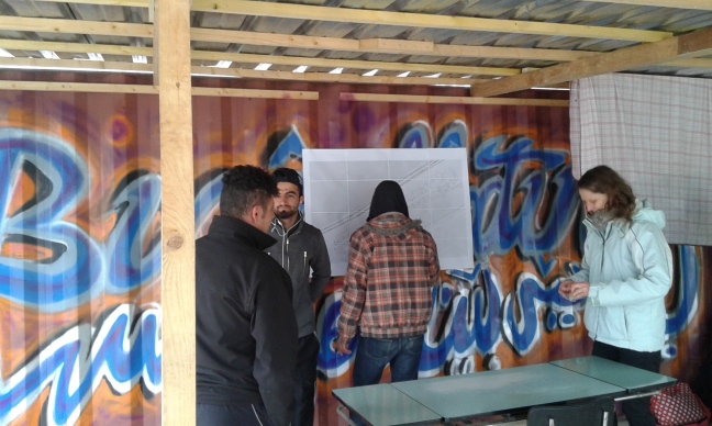
De retour à Dunkerque, l’équipe passe une bonne partie de la nuit à faire du data cleaning, rectifier certains tracés de bâtis maladroits, dédoublonner les données… Katja doit modérer les contributeurs d’OpenStreetMap qui déjà derrière leurs propres écrans s’emparent de la carte, la modifient, l’améliorent. Comme elle le dit – « We don´t need a perfect map (yet). »

Au matin, la première version de la carte est prête, nous l’imprimons et l’apportons au camp. Il est 14h, Grande-Synthe s’éveille sous la pluie. La plupart des volontaires arrivent en même temps que nous. Il n’est de toute façons pas nécessaire de venir plus tôt, beaucoup de résidents ont passé la nuit dehors à essayer de rejoindre l’Angleterre. Ils sont rentrés tard et se lèvent à peine. Certains ne reviendront pas avant plusieurs jours, certains disparaissent. A. et les autres nous rejoignent au compte-gouttes, ensemble nous assemblons la carte que nous affichons sur le conteneur.

Voir la carte d’un seul tenant est un premier aboutissement et cela ouvre de nouvelles perspectives. Nous pouvons enfin prendre du recul sur le travail accompli. Avoir un regard critique. Les résidents s’approchent pointent du doigt des erreurs, des imprécisions. Quid de la traduction en Kurde ? L’un d’eux propose de s’en charger. Il manque les portes d’accès à la zone médicale, bien, A. et moi repartons GPS à la main. Faut-il séparer les douches des toilettes ? Certainement. Ils notent leurs noms à côté de leur shelter respectif. Ils s’approprient déjà la carte. Nous commençons à discuter d’un code couleur, par type de bâtiments. C’est par itération successive que la carte s’affine. D’autres questions fusent. Où afficher la carte dans le camp ? Quel format ? …

Retoucher la carte, Grande Synthe, Avril 2016

Nous terminons la journée en installant l’application OpenStreetMap sur les portables des réfugiés afin que la consultation de la carte soit rendue plus facile, l’édition également. La carte doit continuer à vivre et à évoluer après le départ de l’équipe. C’est impératif. Nous ouvrons un groupe Whatsapp afin d’échanger nos idées entre réfugiés et volontaires, se coordonner.

L’atmosphère change soudain, c’est perceptible. La vie dans le camp ralentit, les enfants rentrent, il est 18h. Ils sont déjà nombreux à se préparer pour la nuit à venir, dehors. À nouveau, chercher à traverser. À tout prix. Le charging center est bondé. Les téléphones toujours en prise. Trouver une route ou joindre un contact.

Sur le chemin du retour, longeant l’A16 et la rocade, nous croisons de nombreux réfugiés. Nous marchons quelques temps avec l’un d’entre eux. Partager sa trajectoire. Un sac et un violon pour bagage. Smartphone à la main. On nous avait vanté les mérites de sa musique dans le camp, mais n’avions pas eu la chance de l’entendre. Il est déterminé à partir. Ce soir. Il bifurque, traverse la voie rapide et se perd derrière le flots de voitures.

Les réfugiés sont les navigateurs modernes, se servant de leurs smartphones comme d’une boussole. À l’ombre de la ville de Jean Bart, l’espoir, parfois, peut tenir à une connexion 3G.

Grande Synthe, Avril 2016

[1] Dana Diminescu, Le migrant connecté, pour un manifeste épistémologique, 2005
[2] Kevin Lynch, The Image of the City, 1960

Refugee Stakeholders

Before, during and after our stay in Grande-Synthe we were asked if there were official requests for mapping activities from stakeholders like NGOs or charities, if we were able to make bonds with them while on site, including options for further collaboration. Yes, we met stakeholders and yes, we made bonds and collaboration is already happening. But the decision makers we mostly interacted with were the camp residents themselves, be it in organised bodies, our mapfugee team members or individuals. They were our most important contacts and collaborators, their support was crucial for a successful and efficent work. Of course, talking to charitable organisations and NGO was part of networking and although important this served more as an additional source of information and input. This is in parts due to the informal situation of the camp which subsequently fosters grassroot structures and self-organisation. Nonetheless the reception of refugee communities as equal partners, take into account their needs and demands, interact with them like any other civil society stakeholders appears to be of crucial importance and needs to be more implemented in humanitarian work. There is not always the place and time to do that, vulnerable persons on their journey or living in miserable conditions might have other needs and demands. But as soon as there is a chance to involve them in the process of improving living conditions, better management and outreach to vulnerable and disregarded individuals, it must be done. They are actors from the beginning on and this has to be acknowledged.

Get involved

The mapping activities in the camps will continue. It won´t be easy. communication and coordination is challenging, there are misunderstandings. The main problem is the lack of equipment, continous training and recruitment of new mappers. We need support on various levels, donations to our crowdfunding campaign are very welcome of course, but providing second hand items like laptop, tablet,  GPS devices, batteries and mice, financing new printed maps and guides for hand-out are of equal importance. Another way to get involved is presence on site: support camp mappers, help with training, interaction with the refugee community and organisations. More topics like connectivity, electricity, mapping apps, map styles are discussed on our mailing list , this is an opportunity to contribute remotely.

Joint achievements

After two weeks of challenges and valuable experiences we are able to present the printed DIN A1 maps at the Refugee Welcome Center. We attach them visibly at this prominent and popular space, where they immediately attract the attention of residents and volunteers passing by. Especially the surroundings map causes a lot of interest and leads to discussions and inqueries. And of course, besides positive response we also get suggestions and critical remarks, which features and names are missing and what should be improved in the rendering.

Small format maps are distributed to the refugee council that will use them to manage the distribution of residents to shelters, and to Utopia56, the association that runs the camp and offered us kind support (and chairs!) during the time of our stay. The translation of the map content to Kurdish and Arabic has been done by our refugee team members. As soon as we have resources these multilanguage maps will be printed and made available to the camp residents.

To finalize and produce printed maps was one of our main deliverable in this project, and we can say we have met this goal, although there are still improvements and refinements needed. But there is now a basemap of the camp and its surroundings that can be built upon and used for various causes: orientation and finding directions  for new arrivals and volunteers, better contingency planning for associations and NGOs, communication and interaction within the camp community as fostered by the refugee council.

Equally important as the provision of accurate and useful camp maps was the training and interaction with the camp residents. We met persons with differing professional background and educational levels, some immediately understood the techniques and procedure of mapping and were able to edit and clean the data independently after a short while, while others preferred to simply go out with fieldpapers and a GPS to collect waypoints and traces. Some joined us only for a few hours, others came nearly everyday. But everyone showed curiosity, open-mindedness and ambition and was eager to transfer the knowledge about their living conditions to an offline and online available map. It was a joy to see their reaction to the many possibilities OpenStreetMap offers, it was hard for them to believe they actually could add to this worldwide database.

All map files and the bus guide are available for download as pdf and png  here

Final review and a Fieldtrip

Our last days were full of intense work, as we wanted to meet also the last goal set prior to the start of the project: digitization and rendering of the data collected on the ground to make it available to camp residents in printed format.  We started printing test maps on the weekend, and exhibited them at the Refugee Welcome Center to give as many people as possible a chance to review and provide feedback. Our trained mappers were by now involved in refining and detailed data editing in JOSM, learned more about tags and good practices in mapping. As usual, new mappers kept dropping in, which gave us the chance to head out once more and collect missing data with GPS. Nearly everyday a new feature pops up at the camp, be it shop, restaurant, bicycle repair, tipi or vegetable beds.

There was a huge demand from the residents to have a map of the camp surroundings (“how to go to…”) So we headed out for a fieldtrip to the nearby lake, the commercial center and busstops. We investigated potential ways to get to the camp, and identified safe routes and alternative directions to those commonly used. To complete this task we had to rely on the knowledge and experience of our refugee mappers who knew much more than us about the dynamics between the camp and the destinations outside.  We discussed and debated what to put on the map and finally agreed to limit the area displayed to the commercial center and a small number of bus stops nearby.

Now we faced the problem how to visualize the missing points of interest like ATMs, post office, Western Union and train station which are situated in the center of Dunkerque which would not be part of our surroundings map. A camp resident threw in the idea of a printed guide in A5 for handout, and use icons and simple Kurdish and English terms to give residents and new arrivals a better orientation and enable them to reach their destinations safely. Combined with the maps we would then have a complete set of points and areas of interest. He invested lots of time and energy in creating this visual guide, from design to translation to communication with the camp residents and associations.

Bus guide.jpg

Mappers from London

By Harry Wood

I joined the mapfugees team last weekend, along with my friend Robert Scott. As big London OpenStreetMappers we’re very close to Dunkirk. This is very convenient, and at the same time it’s embarrassing. After years of participating remotely in Humanitarian OpenStreetMap Team responses to disasters in far flung places like Haiti and the Philippines, I feel embarrassed that something we might describe as a humanitarian crisis, has been playing out just 114 miles from where I live.

So for the two of us, it was a drive and a ferry direct to Dunkirk. The same ferry which the refugees are desperate to get aboard. Arriving at the same ferry port which is heavily fortified with barbed-wire to prevent them doing so. The politics and wider issues of migrants and border controls are complex and pretty unsolveable it seems to me, but arriving at the Grande-Synthe camp, and meeting refugees face to face certainly gave me a new perspective on things.

image1

The first guy I met, used to work in a library in Iraq. After accompanying us on a GPS tracing session to pinpoint the camp library, he invited us for tea in his shelter a few square metres shared with two other guys. It seems to be a popular ritual to share tea and have a long chat, perhaps because they know tea is a big thing in England. We joked that he was only interested in getting to the UK because we’re into tea. He laughed but then said “My friend, we’re not interested in tea, we just want a better life”. He said he’d travelled for a month, including a boat crossing. He had been sharing a shelter with three others, but one of them recently emailed him to say he’d made it to the UK. He described the violent people-smugglers who come into the camp at night, and he appeared upset as he told us they had searched his possessions and taken his Iraqi passport by force.

image2

We did some mapping. Not much mapping, since a lot had already been done, but we added more details: positions of embankments, address numbering corrections, building tag refinements. There were also quite a few new things being constructed in the camp. Whenever possible we involved refugees in the process of mapping the camp. On the second day I wanted to try to load some of their android phones with offline mapping apps (OSMAnd or  MAPS.ME) but we hit quite a few technical issues. The kind of thing I’ve read about other field teams having. Shaky internet connections. Dying batteries. I guess it’s good to experience that first-hand. It gave me a few ideas for better prep next time I’m faced with this kind of thing.

While failing to load android apps, I got talking to another guy. He invited me to drink tea with him and his wife and two cheerful little kids. He had a son aged 6 and a daughter aged 7. They were very friendly and image3welcoming, but spoke little english. I had a very slow conversation with him, using google translate on his phone, and all relayed to his wife. Again they had spent about a month travelling to get to Dunkirk. He had worked as a sports teacher in Iraq. He mimed to explain how they had left because of the constant bombing and gun fire every night. I can imagine there wasn’t much call for sports teachers or any kind of life for his two young kids in that environment. I asked him how much stuff they had travelled with. His wife started crying when he relayed that question. I guess they were once a reasonably well off middle-class family, but they left it all behind and ended up here with nothing but a shed and some blankets. I worried that they might think I was able to help them get into the UK somehow, so I explained that I was just here to try to make life in the camp a little better, by creating a map.

I had that intense conversation just before we had to head off. I feel rather haunted by it. It definitely gave me some things to reflect on, as Robert and I casually waived our UK passports and drove onto the ferry home.

I’m sorry we had to leave so soon, as there is more work to be done helping people use the maps. I hope Katja can continue the fantastic work she’s been doing with a rolling cast of different OpenStreetMappers supporting the mapfugees project at this camp and back at Calais.

Connected refugees

by Quentin, PhD student, Sociology of Migration, University of Telecom Paris Tech

Migrants are the actors of a culture of bonds. This is an agreed postulate in the contemporary migration researches which has never be so true than when you look at the entrance of the refugees camp of Grande Synthe.

The “Charging center” is literally the heart of the camp, this is the first building we meet, even before the kitchen area or the petrol distribution point. Dozens of power lines, chargers and smartphones stack up and get tangled under this old porch. Refugees are waiting, discussing, meeting each other or playing football until their batteries are full again.

26251694912_a7d710b9df_o.jpg

Our mapping process is close to the end, the most distant part of the camp remains to be explore, the living areas too – places to eat, places for the children to play… These areas change all the time : a bike workshop just appears, it was not there the day before. We could spend time and time again there would still be new things to map.

Some refugees are waiting for us to continue the tasks. As I discovered the camp, A. ( who arrives at Grande Synthe only a few days ago ) proposes to make me visit the place and to teach me the good practices of cartographers. He already masters all the tools.

Our approach combines GPS and field papers that A. live annotates, following the middle road of the camp. He puts POI, then a row of trees, a “Coffee Shop” that he insists to rename “Coffee and Tea Shop”. Well naming the places is important, making his own mental map of the camp to become reality. I mark with the GPS all the points he chooses to highlight. We navigate from place to place, building his personal wayfinding process through his relation with the camp. We reveal the structure of the camp, this will be really useful for the other associations in the goal of future developments planning.


Mapping the camp with A is also the occasion for him to tell me his story, his journey. He reveals himself. We meet other refugees, speak with them, they are curious, interested in what we are doing, mapping the camp his definitely a way to create new links, new connections between residents, between volunteers. We discover that in term of mapping, the needs of the refugees are already far from the camp, they want to know how to go safely to the lake to find fishes, how to go to town center, how to go outside …

DSC_0530.jpg

We continue with the digitalization of our work. Pointing out, drawing , categorizing and uploading everything to open street map. We must act quickly, our computers have limited autonomy, even for us, the life of a battery is important. The camp as a whole seems to be organized around this need of recharging.

A.and me become friend on facebook and take a lot of selfies. His smartphone is full of app, much more than mine. Facebook, whatsapp and viber are the most used. Sygic gives him a GPS without internet connection,n to find good direction during the journey. He speaks with his family, his parents or his friends who are still in Iraq. Applications help him to increase his desire of presence, being here and there at the same time. Refugees are the modern navigators, using smartphone as a compass.

At the end of the day the camp empties slowly, there is less agitation but the “Charging Center” is still full of people, trying to get a network. How many of them will attempt the crossing tonight ? Keeping hope may sometimes be only the result of a living 3G connection.

Filling in the grid

Our fourth day in the camp, and we start to be known a bit… We get a hug on our arrival from a Utopia volunteer and a big smile from the guys who mapped with us yesterday. Today we brought not only our five gps-devices, but also equipment to get the mapping really started!

We installed our table and chairs and most importantly, the router connected with a solar panel which will provide us with internet connection (thanks Bibliothèques sans Frontières!). While Johan and Blake were setting up our little mapping headquarter, Katja and Jorieke started already to explain to curious refugees what we are doing: make them making a map of their own living environment!

Thanks to work of Jo and Blake the day before, we could print today also our first field papers. With help of the plan made by MSF for the initial construction of the camp, we were able to add the footprints of the shelters and buildings on OpenStreetMap which we subsequently printed in full color with the printer donated to the project by Jo.

Once on site, we started to learn some interested refugees how to map the camp with help of the field papers. It was amazing how fast they learned! “In the north of the camp, you see the highway, and in the South you see the train. Then at the entrance you see the charging center, you know, that place where you go to charge the battery of  your phone when it died.” Those are clear reference points for the refugees which consequently were mapped out the first.

It was a day of running around with gps’s and field papers. We as externals got to know again a bit better the camp, but also the residents learned more about their actual living environment, especially the new arrivals. About 10 new persons arrive every day. For them a map of the camp could be a real asset; to find the adult school, the entrance to the doctors, the mothers and children center, etc.

With three refugee mappers continuously at our side, the setup of our little mapping corner and curious residents all around us, we could say this day was a success!

See the post on Facebook.

Mapping starts!

The Welcome Center turns out to be the a spot designed to get in contact and attract people. We furnished our mapping corner with a foldable table and chairs. Within short time a few curious people approach us, wanting to know more. We show the blank map, talk about potential problems new arrivals and refugees with poor English knowledge face without an adequate map. As we find out, the rapid growth of the camp even challenges long-term refugees.

The field mapping is done in buddy teams of two for efficiency and safety reasons, collecting GPS data on the go. After a short explanation of the device menu and its main functions, we start in the surrounding of the Welcome Center, marking the POI with waypoints and taking notes in order to create a skeleton of the structure. Light Poles serve as points of reference, combined with the data from the main “middle street “ the divide the camp in sections. The teams collect data and information of the entrance and new arrival area which includes the charging place, medical clinic, laundry and petrol distribution point.

The lack of communal spaces, food and NFI distribution points in the backmost, single men part of the camp, where 60% of the camp population lives is obvious. The area is deserted, shelters are not personalized, only few open fires and cooking activities, apparently residents of this area prefer to spend their time in the entrance and family area  as it offers multiple attractive options to interact, play and communicate. This fact may relate to the presence of human traffickers, cigarette smugglers and drug dealers in the back part of the camp, leading to violence, tensions and a feeling of insecurity and threat for the residents in this area. The mafia gang activities and fights occur exclusively during the night, preventing the residents not involved from finding sleep and rest. This results in a reduced ability to participate in camp activities concentrate and organise and adds to already existing mental health issues like PTSD, depression and anxiety.

See this post on Facebook.

Installation and Set-up

During the time of our stay the technical equipment is made available by the NGO Bibliothéques sans Frontières (BsF). It consists of laptops, tablets, GPS Devices, solar panel, battery and router. Other than planned we settle in the “Welcome Center” which is located in the heart of social activities, sheltered by a tin roof, a perfect spot for outreach and interaction with refugees walking by. Our previous plan to do the workshop in the large charging station is cancelled, we have been informed by camp residents of the presence of smugglers and dealers in this area. We visit public places like the school, talk to students, teachers and residents we meet on our way through the camp and get invited to sit down for a tea.

Pre-Arrival

Team members Mark and Jorieke visited the Grande-Synthe refugee settlement a week before the real start of the project. They spent a lot of time getting to know the dynamics of the camp and the needs/requirements of the individual stakeholders. While being in the camp they discovered an already existing map of the camp (made by MSF) which can be seen in two of the staff cabins. However, the constant evolution of the camp makes the map unfit for purpose and so lack of use of the map was observed.

The conclusion of this first visit was, that there are numerous stakeholders that would like an up to date map. However, the camp staff, such as the teachers, and residents (with mothers, youth/children, as subsets) all have different requirements. Key stakeholders like the school headteacher and members of the refugee council should be able to support us with getting set up on the ground and with collecting the wishes of the camp residents and staff. While we, the team, can say what we think is required to map, it will give the residents and staff ownership over the map if they do it.

For the initial mapping survey, it was clear that there is a dynamic from within the camp – the staff are primarily interested in the form of the camp, how it’s growing and how things getting organized, this in contrast with the residents who have needs on understanding the immediate vicinity of the camp. This comes from the perspective of mapping local amenities, such as hospitals and bakeries to ones of safety. The camp is bordered by a motorway and train tracks, as such it is common for the camp residents to venture out onto the motorway and train tracks to get somewhere, as a clear route to where they want to go isn’t know. This has been a safety risk. With the train tracks, there is also the disinformation that they go to England, this causes the residents to attempt to jump on the trains, with ambiguous results.

What the camp staff and residents certainly would like to see on the map:

  • Amenities of the camp and local surroundings
  • Local bus routes that serve or go near the camp
  • Potential to demonstrate “how do I get to Dunkirk” … “take the A1 bus from X stop”
  • Access routes in and out of the camp

The storage of the mapping equipment could be supported by the camp school. Currently the school head teacher is overseeing the construction of lockable lockers for the eventual storage of the equipment. There is a single point for electricity in the camp – which is also the main area for socialising. This has a rather large wall, where we can hang maps of the camp and the surrounding areas -we can work with the Camp Council to present the findings and process of the work.

Internet in the camp is intermittent to non-existent, there is no wifi. Opinion by residents is that the signal is “being blocked by drones”. This is regardless of a high 3G signal. Testing out different 3G networks for connectivity should be the first step to tackle the problem.

Once a basemap of the camp has been established, there is a strong desire for participatory mapping, with mothers, children and other groups to further identify and capture data. This could be done on top of the printed maps, in schools, dining areas and ‘in’ the camp itself. As an aside, the school would be quite grateful for maps of the camp and surrounding areas for geographical learning. And as an added value – the residents also quite like a little app for the camp, that allows for the map to be seen offline on their phones.

Generally, there is good desire for our project in the camp, and with the resources that we have already we can do a very good job. Our next steps now are writing check-lists for practical implementation and steps for the on-the-ground mapping.

See this post on Facebook.